LOWLEVEL is in private beta — access is by invitation
LOWLEVEL
Sign in
§ Surfaces · the three you useProduct screenshots

Look. Decide. Fly.

Three screens do the work: the one that says whether there is anything to do today, the one that explains why the engine asks for what it asks for, and the one that warns you while it can still be fixed.

entries · in the catalogue
10
aerodromes · with frequencies
582
protected · areas
3.796
documents · indexed
26
§ Detail · the three, one by one§ 02 · the surfaces

Three screens. One place to look.

Shoots this month
14
+4 vs last month
Filings within lead time
9/9
100% vs last month
Flight hours
36.5
+6.2 vs last month
Docs expiring soon
2
-1 vs last month
Flights · 2026
182+38 vs 2025
MonthlyWeekly
Jan
Feb
Mar
Apr
May
Jun
Jul
Aug
Sep
Oct
Nov
Dec
Upcoming shoots
5 scheduled
  • FdCM
    Faro de Cabo Mayor
    sunrise · A1
    12 Aug
  • PdR
    Polígono de Raos
    industrial · A3
    14 Aug
  • PdS
    Playa de Somo
    surf · A1
    16 Aug
  • PdE
    Picos de Europa
    documentary · A2
    21 Aug
  • BdS
    Bahía de Santander
    marine · A1
    24 Aug
Wind · next 24h
12 ktgusting 19 kt
24h7d30d
Provinces flown
  • Cantabria42%
  • Asturias18%
  • Bizkaia14%
  • Burgos11%
  • Madrid8%
  • Others7%
UAS zones checked
Last 30 days
Zone
Lookups
Requirement
Ceiling
LEC Santander TMA
1,204
coordination
120 m
Parque N. Picos
847
authorisation
—
ZEPA Marismas
512
restricted
50 m
Urbano Santander
391
A2 · insurance
120 m
Costa Quebrada
284
A1 · open
120 m
Permits and filings
8 open
Filing
Shoot
Status
Body
Margin
Deadline
OPS-014
Faro de Cabo Mayor
Approved
AESA
8 days
2026-08-12
OPS-015
Polígono de Raos
Filed
MIR
5 days
2026-08-14
OPS-016
Playa de Somo
Approved
City council
12 days
2026-08-16
OPS-017
Picos de Europa
Expired
National park
—
2026-08-01
OPS-018
Bahía de Santander
Approved
Harbourmaster
9 days
2026-08-24
OPS-019
Camino de Santiago
Approved
AESA
15 days
2026-08-28
OPS-020
Vega del Pas
Filed
MIR
3 days
2026-08-30
OPS-021
Castro Urdiales
Approved
City council
11 days
2026-09-02
Activity
  • E
    Engine recalculated the lead times for OPS-015
    2m ago
  • MR
    Marta R. uploaded the Somo flight plan
    8m ago
  • A
    AESA approved application OPS-014
    14m ago
  • W
    Weather gust warning, 38 km/h on Thursday
    22m ago
  • IT
    Iván T. completed the pre-flight checklist
    31m ago
  • E
    Engine found a UAS zone over Raos
    45m ago
Conversion rate
3.24%+0.4% vs last week
M
T
W
T
F
S
S
Flight window
99.98%Thursday 12 · wind ok
30d agotoday
OPS-015 · evaluation
Live
09:14:02▸shoot.eval OPS-015 · Polígono de Raos
09:14:02▸zone.uas LEC-R Santander TMA · 120 m
09:14:03▸notam.check 2 in force on the date
09:14:03▸enp.miteco nothing on record over the point
09:14:04▸filing.mir required · lead time 5 days
09:14:04▸filing.city Santander · lead time 12 days
09:14:05▸weather.window Thursday 07–13h · 12 kt
09:14:05▸checklist.preflight generated (14 items)
09:14:06▸deadlines computed backwards
09:14:06▸shoot.state PERMITS_PENDING
03:17100%
LOWLEVELEXPIRESDrone liability coverDJI Mini 4 Pro · policy 7741
9days
to renew
№ 01First thing in the morning
The dashboard

What expires, which filing has a lead time and which shoot is next. What decides whether there is anything to do today.

№ 02Why it says what it says
The engine trace

Every line is a real step: UAS zone, NOTAM at that hour, protected area, the entry that applies. Auditable, not a black box.

№ 03While there is still time
The alert

The insurance expires on the 10th and the shoot is on the 14th. That is not a data point: it is a decision to make today.

№ 01First thing in the morning

What you have ahead of you.

Expiry dates, filings with a lead time and the next shoot. One screen that answers “is there anything to do today?” without opening anything else.

  • The alert first, and the worst number at the top
  • Filings sorted by deadline, not by when they were created
  • Active projects and the next shoot
4 daysof margin · before it expires
№ 02Why it says what it says

No black box.

Every filing that comes out has a trace behind it: what was queried, what came back and which entry was applied. If you cannot audit it, you cannot defend it to whoever asks.

  • ENAIRE's UAS zone, NOTAM at that hour and height, protected area
  • The entry that applies, with its official source and its review date
  • Deterministic: the AI explains, it does not decide what is required
10 entriesin the catalogue · evaluated per flight
№ 03While there is still time

The insurance expires before the shoot.

We check expiry dates against the dates of your shoots. A certificate that runs out on the 10th is not a data point: it is the shoot on the 14th losing its cover.

  • Insurance, ratings and documents, checked against every date
  • It arrives with time to fix it, not the day before
  • It shows on the dashboard even if you never open your email
14 Augthe shoot that would be left uncovered

// 01 · The journey

From the location to the portfolio

A drone shoot comes down to four decisions made well. LOWLEVEL lines them up with official data behind them and shows you, at each one, where the data comes from and how current it is.

01

Tell us where and when

Create the shoot with its location and date. The map shows you whether the point falls inside an ENAIRE UAS zone, whether any NOTAMs are active at that hour and height, and whether it touches a protected natural area.

ENAIRE servAIS (ED-318) · MITECO/IEPNB

02

The engine computes the filings

From where, when and the weight of the equipment you carry that day, the engine decides which permits that flight requires and works out each deadline backwards from the day of the shoot. Deterministic and auditable: the AI never decides what is required.

Spanish regulatory catalogue, maintained centrally

OPS-015 · evaluation
Live
09:14:02▸shoot.eval OPS-015 · Polígono de Raos
09:14:02▸zone.uas LEC-R Santander TMA · 120 m
09:14:03▸notam.check 2 in force on the date
09:14:03▸enp.miteco nothing on record over the point
09:14:04▸filing.mir required · lead time 5 days
09:14:04▸filing.city Santander · lead time 12 days
09:14:05▸weather.window Thursday 07–13h · 12 kt
09:14:05▸checklist.preflight generated (14 items)
09:14:06▸deadlines computed backwards
09:14:06▸shoot.state PERMITS_PENDING
03:17100%
LOWLEVELEXPIRESDrone liability coverDJI Mini 4 Pro · policy 7741
9days
to renew

03

File it without copy-paste

The Chrome extension fills in the Spanish Ministry of the Interior's form with the data from the shoot. You review it and sign with your certificate — the extension submits nothing for you.

LOWLEVEL extension for drones.ses.mir.es

04

Shoot with the window in your favour

Daily and hourly weather for the date, field checklists, logbook and fleet maintenance. When you are done, the piece goes to your public portfolio on your own subdomain.

Your own subdomain on every plan, the free one included

// 02 · The funnel

One point. Five layers. One orientation.

What sets us apart is also the hardest thing to explain: where everything the product says about a point comes from. Here is the whole route over a real point on the Cantabrian coast, layer by layer, each one with its source and its date.

The example point

Cabo Mayor · Santander

43.4917 / -3.7925

The question is asked for a 0.05° box around the point —about 5.5 km— which is the box the app asks for around a GPS fix and the same cell the cache snaps to. That way this section shares its upstream call with the public map instead of adding one.

No map is drawn here: loading one would cost 242 KB of MapLibre on a page meant for reading, and what this section shows is the data, not the canvas.

  1. 01

    UAS geographical zones

    Live

    What does ENAIRE publish about the airspace over this point, from what height and up to what height?

    Published limits

    • SANTANDER/Seve Ballesteros-SantanderAuthorisation required0 M AGL → 900 M AGL
    • SANTANDER/Seve Ballesteros-SantanderAuthorisation required45 M AGL → 900 M AGL
    • CTR SANTANDERAuthorisation required60 M AGL → 305 M AGL
    • TMA SANTANDERAuthorisation required305 M AGL → 4420 M AMSL
    • ATZ SANTANDERAuthorisation required60 M AMSL → 4633 M AGL

    ENAIRE updated them on 8 Jun 2026

    These are the polygons ENAIRE returns for the box, exactly as they arrived. Which polygon contains the exact coordinate, and at what height it reaches you, is the per-point check the studio does.

    ENAIRE servAIS (ED-318)

  2. 02

    Protected natural areas

    Not checked here

    Does the point fall inside a protection designation, and who manages it? For a protected area, the useful fact is who you ask for authorisation: the body that grants it is the area’s managing body.

    3.796 polygons loaded for this layer

    Fuente: © Ministerio para la Transición Ecológica y Reto Demográfico (MITECO) · IEPNB

    The dataset date travels with every row and is shown beside the answer, inside the studio. This page does not check the point against that layer.

  3. 03

    NOTAM

    Not checked here

    Is there a NOTAM covering the hour and height of the flight? A NOTAM is free text with its own published validity period, so the time window is what decides.

    ENAIRE · NOTAM service for UAS

    It is queried with the date, the hour and the height of a specific shoot, and there is none here.

  4. 04

    Obstacles and aerodromes

    Not checked here

    What is nearby that forces coordination? An aerodrome with its radio frequency, a published obstacle.

    582 aerodromes with their frequencies

    Aerodromes: OurAirports · public domain

    It depends on the radius the shoot sets; it is not queried here.

  5. 05

    Terrain and elevation

    Not checked here

    How much does the terrain rise under the point? Without that, a height band in metres above ground cannot be compared with anything.

    Elevation: Copernicus DEM GLO-90 via Open-Meteo

    90 m cells, so a cliff is averaged out. It is queried with the height of the flight, and there is no flight here.

The orientation

Around this point, our sources record 5 UAS geographical zones published by ENAIRE, as of the date above. What each one requires is set by its own type, shown right beside it, and the authorising body is ENAIRE.

The other four layers are not queried on this page, so this is not the orientation of a flight: it is missing the protected area, the NOTAM for the window, the obstacles and the terrain. Check the airspace in ENAIRE’s official viewer before you fly.

Checking your own point happens inside the studio and needs an account; the beta is by invitation only.

Assistant · the AI inside the studioFig. 01

One question, answered.*

* This is not legal advice. The assistant cites the source and its date; the engine decides which filings are needed, and the operator remains responsible for checking with AESA. The answer and its sources are quoted as the regulator published them, in Spanish.

Query 01Queued
?

Ans

3 filings in our catalogue · the longest lead time is 10 days

  • Operator registration0
  • Liability cover in force0
  • Prior notification10
Query 02Queued
?

Ans

Según el Reglamento (UE) 2019/947, 120 m sobre el terreno y sin sobrevolar a personas ajenas

  • Reglamento UE 2019/9473
  • Guía AESA2
  • RD 1036/20171
Query 03Queued
?

Ans

The liability cover expires on the 10th · it does not cover the shoot

  • Liability cover4
  • A2 rating96
  • Battery service40

The LOWLEVEL app

LOWLEVEL on your phone and on your iPad

It installs on iPhone, iPad and Android and links to your studio with a code the studio issues: no second password. What you check in the field is read on the phone; creating and editing stay in the browser.
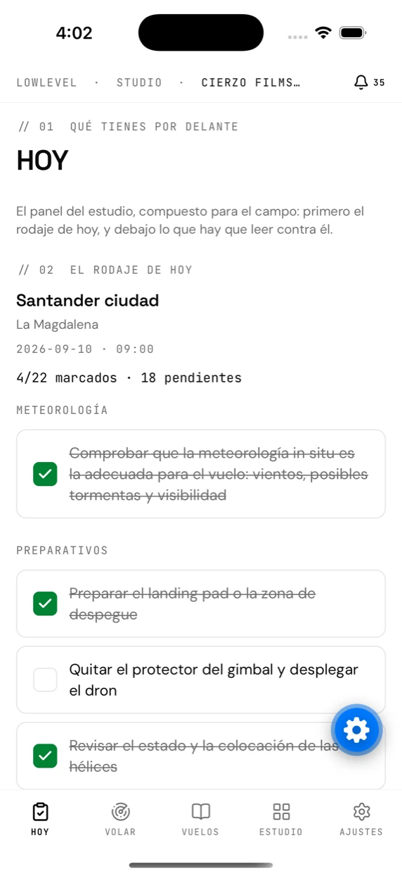
The app’s “Today” tab, with the day’s shoot and its checklist

The day, before you set off

Today’s shoot with its checklist, the documents that expire soonest and anything this phone still has to send. Lines you tick with no signal are saved on the phone and sent automatically when the connection comes back.
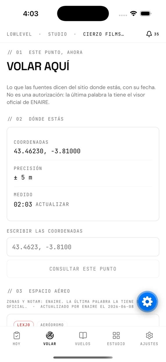
The app’s “Fly here” tab, showing the zones over the phone’s position

“Fly here”, wherever you are

ENAIRE’s UAS zones at the phone’s own position, what each one requires in its own words, the forecast for the hour, aerodromes and protected areas. Every reading carries its date, and ENAIRE’s own viewer still has the final word.
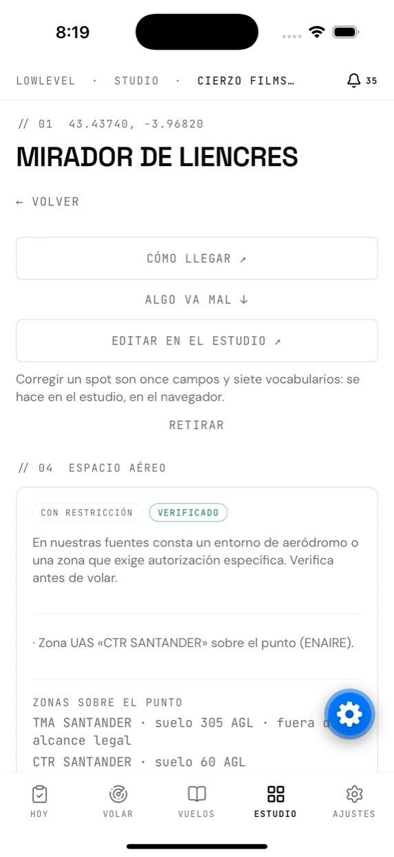
A community spot’s card in the app

The walk to a spot

You record the walk from where you park, with the phone in your pocket and the screen off. When you stop, the route is uploaded to the spot’s card for whoever comes next.

Closed beta

TestFlight in the coming weeks. It is not on the App Store or on Google Play yet, so there is nothing to download here.

If you already have a studio, sign in and link the phone from SettingsLink the app.

// 03 · Who it is for

One engine. Two ways of using it

For the love of it

You fly at weekends and want no nasty surprises

The expensive part of flying for fun is not the drone: it is finding out too late that the place required a filing. That is what we take off your hands, for free.

What each place asks for
Tell us your city and how far you are willing to travel; places come back sorted by what really decides it.
Community spots
Take-off point, obstacles, best season and how it went for those who have already flown there.
The Ministry filing, handled
The extension fills in the Ministry of the Interior's form with the data from your flight. You sign it.
Your logbook
Hours, aircraft and place. What you will be asked for, on the day someone asks.
An assistant that cites
Ask in your own language; it answers with the official source and its date.

Gratis plan · one project, unlimited shoots, no card

For work

You invoice flights and the paperwork is half the job

The client sets the date and you have to make it. The engine computes the lead times backwards from the day of the shoot, so on Thursday you know what you cannot promise for Saturday.

Projects and shoots
Status, location, assigned crew and the checklist ticked off in the field.
Airspace by location
ENAIRE's UAS zones, NOTAM at that hour and height, and MITECO's protected areas.
Fleet and maintenance
Aircraft, batteries, servicing and the hours on each one.
Documents that read themselves
Upload the insurance and the AI pulls out the expiry date; the alert arrives before the shoot it would leave uncovered.
Storyboards from the plan
Frames with shot type and camera movement, built from the shoot you already have set up. Piloto plan and above.
Portfolio on your subdomain
The finished piece at your-agency.lowlevel.studio, free on every plan.

Piloto, Estudio and Productora plans · no cost per member

// 04 · Private beta

Your next flight, legal from the plan

We are opening LOWLEVEL by invitation, to refine it with people who really fly. Request access and we will get in touch.