LOWLEVEL is in private beta — access is by invitation
LOWLEVEL
Sign in

Plan it. File it. Shoot it.

The back office for anyone flying drones in Spain: permits and their lead times, airspace, weather and portfolio in one place. It is not the wind that moves your shoot.

3D model DJI Inspire 2 by Leon Heytens · CC BY 4.0 · adapted

// 01 · Two ways to fly

One engine, your way of flying

Path A · For the love of it

Fly legally, without the paperwork in your head

You fly at weekends and would rather not risk a fine for not knowing what that area requires. LOWLEVEL tells you before take-off, for free.

  • →One project, with unlimited shoots
  • →Which permits your flight needs, with their lead times
  • →The Ministry of the Interior filing, through the extension
  • →A regulatory assistant that cites Spanish regulations
  • →Your public portfolio, to show your work
  • →A community of flying spots on the map

Gratis plan · no card

Path B · Production

The whole operation, under control

You shoot for clients, and every flight brings permits, lead times, fleet and crew with it. The engine works out each deadline backwards from the day of the shoot.

  • →Projects and shoots with status and assigned crew
  • →Airspace, NOTAMs and protected areas, by location
  • →Daily and hourly weather for the shoot date
  • →Fleet, maintenance, logbook and checklists
  • →Documents with expiry-date OCR, and alerts
  • →Storyboards generated from the flight plan

Piloto · Estudio · Productora plans

What it does, at a glance.

Where to fly — a real screen from the studio
Where to fly
Six capabilities · from A to FHover to see it
A.
Where to flyWe tell you what each place requires, not just where not to goTell us your city and how far you are willing to travel. Places come back sorted by what really decides it: what is on record in the airspace above each one, how far you have to walk and which filing it requires.
B.
Airspace582 aerodromes and 3.796 protected areas, already loadedENAIRE's UAS zones, MITECO's protected natural areas and aerodromes with their frequencies. The map is coloured by difficulty, not by layers you have to interpret.
C.
FilingsThe paperwork THIS flight requires, with its lead timesA shared catalogue of the Spanish rules, maintained by us. Every entry carries its official source and the date it was reviewed — and when it changes, it changes for everybody at once.
D.
AlertsYour insurance expires before the shoot. We tell you in timeExpiry dates of insurance, ratings and documents, checked against the dates of your shoots. The alert arrives while there is still time to fix it.
E.
ProductionProjects, shoots, fleet and logbookWhat you keep in spreadsheets and folders today: crew assigned to each shoot, maintenance, flight hours and checklists ticked off in the field.
F.
AssistantAsk in your own language; it answers citing the source26 official documents indexed. The assistant EXPLAINS the rules and cites the passage with its effective date; what decides which paperwork is needed is still the engine, which can be audited.

New in September

Before take-off.

What the studio checks about your shoot before you fly, layer by layer: every fact with its source and its date, and what it does not know, said out loud. It advises; the last word belongs to the authority and its official viewers.

During the beta everything is open, on every plan. When the beta ends, each feature stays in the plan its label names.

The shoot’s traffic light

Nine layers in one status, each with its source and its date.

Studio screen: the traffic light of a demonstration shoot on the Magdalena peninsula, with paperwork pending and the ENAIRE zones that reach the operation
What it does
Brings together in one status what our sources say about your shoot: paperwork, UAS zones and controlled airspace, the NOTAMs that reach your time window, protected areas, weather, geomagnetic activity and satellites. It adds the distances from buildings that Spanish rules set for each assigned aircraft (with the Cadastre’s footprints), the populated areas that count for the A3 subcategory and the infrastructure zones ENAIRE publishes.
What it does not do
It does not grant permission to fly. If a layer could not be checked, it says so and does not count it as clear. Critical infrastructure is not public and is not in our sources; the courtyards and recreation areas the rules also protect are not in the Cadastre.
Which plan
  • Traffic lightGratis
  • Distances from buildings, A3 and infrastructureGratis
  • NOTAMsGratis
Sources
ENAIRE · MITECO · Cadastre · NOAA · Open-Meteo · CelesTrak

The shoot and the flight in 3D

Terrain, buildings and UAS zones with their name and band, at your height.

Studio screen: the shoot in 3D over the Magdalena peninsula, with the 120 m ceiling around the take-off point and, over the map, the UAS zones that hold that point with their published band
What it does
A 3 km square around the take-off point: terrain, buildings, ENAIRE’s UAS zones named with the band they publish (the ones that hold the take-off point, stated over the map), your operation at its planned height and the sun at the time of the shoot. In the analysis of an imported flight, the track over that scene and a height profile that says between which minutes the aircraft was inside each zone’s outline and on which side of its band.
What it does not do
It is a visual reconstruction, not a measurement: a building’s height is an estimate from its floors, and a limit above sea level is placed using the terrain. Whether a zone reaches your height is still stated by the operations map. It is not loaded on a phone: the same facts arrive as text.
Which plan
  • The shoot in 3DGratis
  • The flight in 3DFrom Piloto
  • Cadastre heightsFrom Piloto
Sources
ENAIRE · OpenStreetMap · Cadastre · Terrain Tiles (EU-DEM)

Visible trafficExperimental

Aircraft with ADS-B, and gliders and paragliders with FLARM.

Studio screen: the map of a demonstration shoot in the Casa de Campo with the traffic layer on, the aircraft with their altitude and the fixed notice about what does not appear
What it does
The aircraft that broadcast their position within 15 km of the shoot and below 10,000 ft: ADS-B through adsb.lol, and FLARM or FANET (gliders, paragliders, hang gliders) through the Open Glider Network. It refreshes every 10 seconds, only while the layer is switched on.
What it does not do
It is situational awareness, never separation: many aircraft do not broadcast their position or no receiver hears them. The altitude is the pressure altitude or the device’s own GNSS, not the height above your drone. No registrations or call signs, and nothing is stored.
Which plan
  • Visible trafficGratis
Sources
adsb.lol (ODbL) · Open Glider Network (ODbL)

Weather aloft

Choose the model; wind aloft, shear and density altitude.

Studio screen: the weather of a demonstration shoot, with the wind at 80 m, the shear and the density altitude of the time window
What it does
Choose the forecast model and see, hour by hour, the wind at the published level just above your maximum height, the shear against the wind at 10 m and the density altitude. The judgement on the shoot’s window stays on every plan.
What it does not do
The thresholds are generic multirotor ones, not your aircraft’s, and the shear warning from 5 m/s is a threshold of ours. Density altitude is information: it is not judged. If a model does not publish a column, that is said rather than taken as fine.
Which plan
  • Forecast, judgement, wind aloft and shearGratis
  • Model choice, density altitude and AEMETFrom Piloto
Sources
Open-Meteo (ECMWF and other models)

The light of the shoot

Golden and blue hours, sun and shadows in your window.

Studio screen: the light of a demonstration shoot, with dawn, sunset, the golden hour and the sun every quarter of an hour of the window
What it does
Civil dawn and the end of civil dusk, sunrise and sunset, the golden and blue hours, and for every quarter of an hour of your window the sun’s elevation and azimuth, with where the shadow falls and how many times the height it measures. An astronomical calculation, for any date.
What it does not do
It does not count terrain or buildings on the horizon. It informs and does not decide: whether the flight is at night is for you to mark.
Which plan
  • Light of the shootGratis
Sources
NOAA astronomical calculation (Meeus)

GNSS satellites

GPS, Galileo, GLONASS and BeiDou, hour by hour, with their DOP.

Studio screen: the GNSS satellites over a demonstration shoot, with the hourly table and the geometry of the window
What it does
How many satellites of the four constellations stay above the elevation mask at your point, hour by hour, and what their geometry is like (PDOP, HDOP and VDOP). With the surrounding terrain, also the ones the mountains hide.
What it does not do
It counts satellites by their orbit, not by their signal: it does not measure interference, jammers or reflections, and we do not know which systems your aircraft tracks. The PDOP 6 threshold is ours, not a regulatory one.
Which plan
  • Open skyGratis
  • With terrainFrom Piloto
Sources
CelesTrak (GP orbits) · Copernicus GLO-90

Mobile coverage

The ministry’s official map, centred on your point.

Studio screen: the mobile coverage of a demonstration shoot, with what needs a network and the links to the official 5G and 4G maps
What it does
If you need a network at the point (RTK, live streaming, telemetry or downloads), you note it on the shoot and we remind you on its record, on the field checklist and in the flight manual, with the link to the official 5G and 4G map centred on your coordinates.
What it does not do
It is the coverage the operators declare, on the ground and outdoors: it is not a measurement and says nothing about the signal at height. We do not store its data: the ministry’s viewer opens.
Which plan
  • Link to the official mapGratis
Sources
Ministry for Digital Transformation · data as at 30 Jun 2024

Real screens of the studio, in Spanish, over demonstration shoots at public places: the Magdalena peninsula (Santander) and the Casa de Campo (Madrid); the 3D, over a demonstration flight at Cuchía (Miengo), with the real ENAIRE zones. The traffic is drawn over a recorded adsb.lol response.

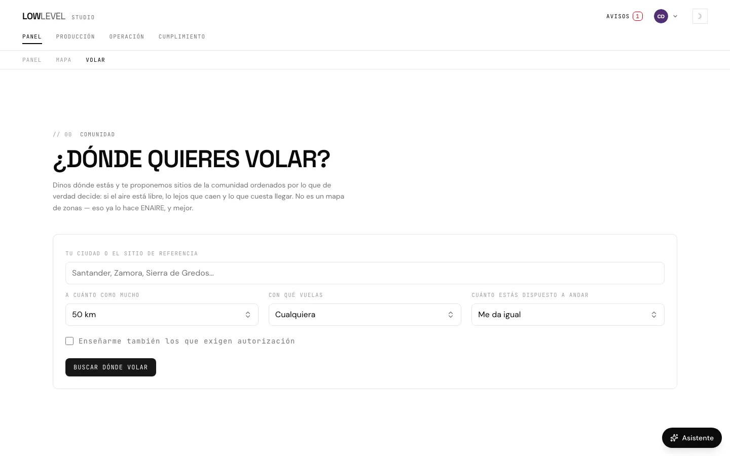
Where do you want to fly?

Spots the community has marked, with what ENAIRE and MITECO say about each one, how to get there and how the flying is. And from any of them, the shoot planned in one click.

The search lives inside the studio: sign in with your account. During the closed beta access is by invitation — join the waiting list

§ Alerts · what needs your attention today

The alert arrives while there is still time.

The LOWLEVEL app

LOWLEVEL on your phone and on your iPad

It installs on iPhone, iPad and Android and links to your studio with a code the studio issues: no second password. What you check in the field is read on the phone; creating and editing stay in the browser.

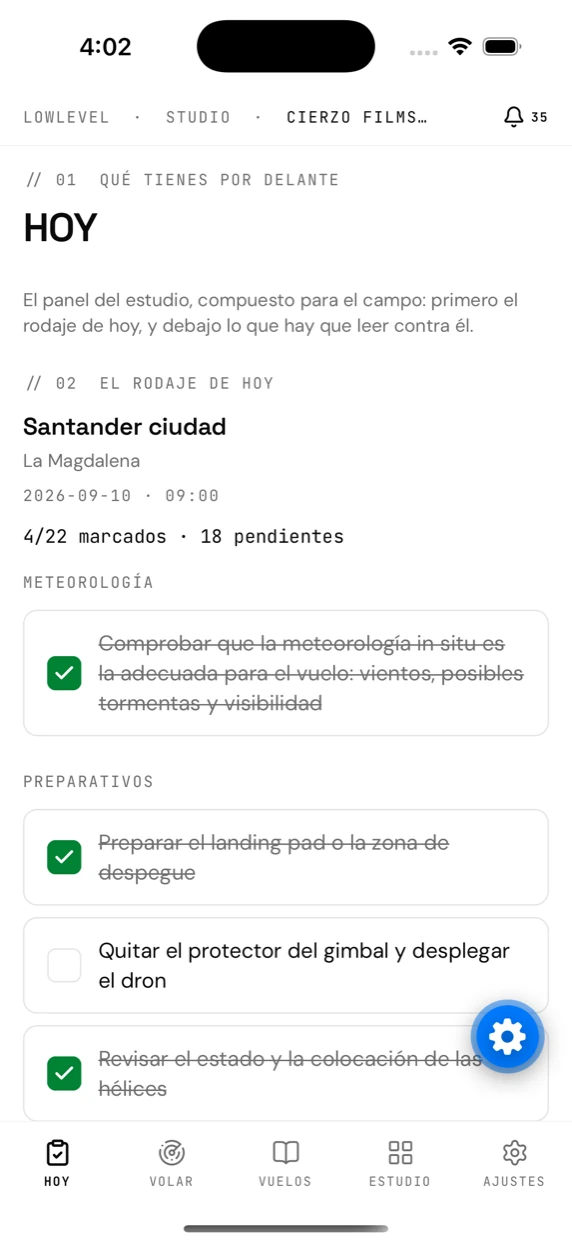
The app’s “Today” tab, with the day’s shoot and its checklist

The day, before you set off

Today’s shoot with its checklist, the documents that expire soonest and anything this phone still has to send. Lines you tick with no signal are saved on the phone and sent automatically when the connection comes back.

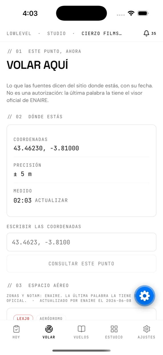
The app’s “Fly here” tab, showing the zones over the phone’s position

“Fly here”, wherever you are

ENAIRE’s UAS zones at the phone’s own position, what each one requires in its own words, the forecast for the hour, aerodromes and protected areas. Every reading carries its date, and ENAIRE’s own viewer still has the final word.

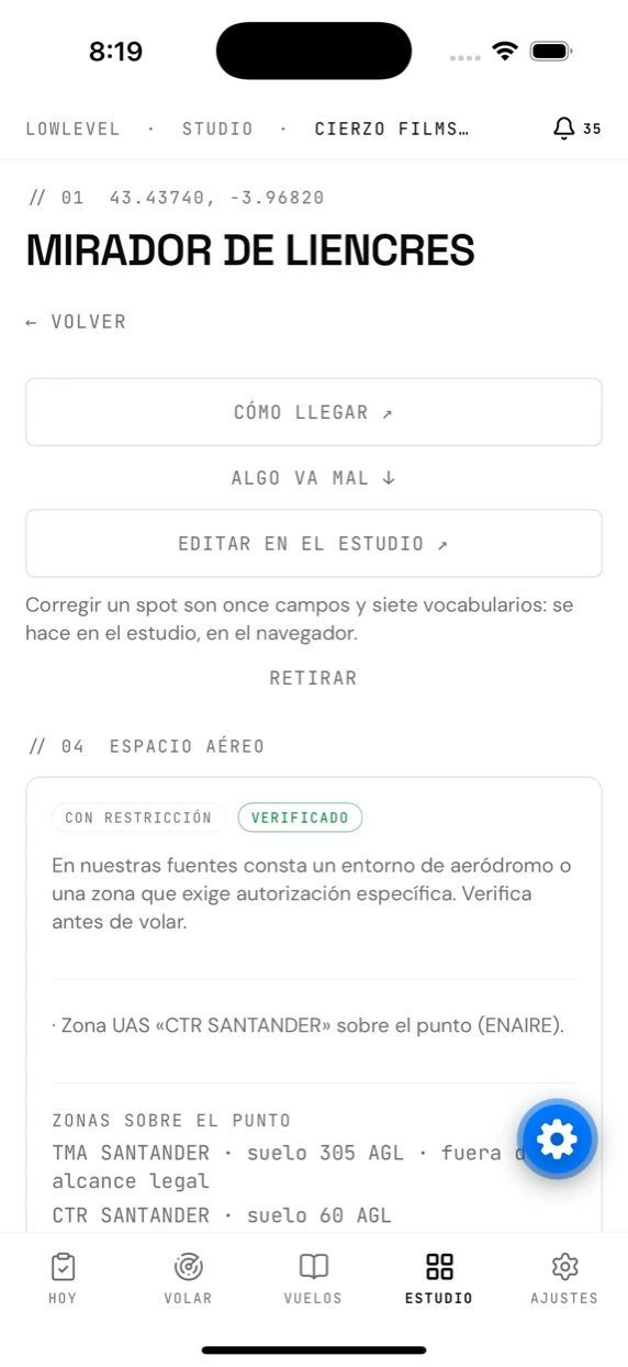
A community spot’s card in the app

The walk to a spot

You record the walk from where you park, with the phone in your pocket and the screen off. When you stop, the route is uploaded to the spot’s card for whoever comes next.

Closed beta

TestFlight in the coming weeks. It is not on the App Store or on Google Play yet, so there is nothing to download here.

If you already have a studio, sign in and link the phone from SettingsLink the app.

Regulatory catalogueAESA · ENAIRE · MITECOEvery entry, with its source and its date
What you are actually paying for

The rules change. So does the catalogue.

LOWLEVEL maintains a shared catalogue of the filings a drone flight needs in Spain and applies each entry only to the flights it affects, by location, time and equipment. When the rules change, it is updated once and reaches everybody — nobody has to find out on their own. Every entry shows its official source and when it was reviewed, and you can switch it off or add your own.

  • 582
    Aerodromes with their frequencies
  • 3.796
    Protected areas loaded
  • 19
    Autonomous communities and cities covered
This is not legal advice. It is the groundwork, done.
7 comparisons · one by oneWith LOWLEVEL · without LOWLEVEL
With LOWLEVEL
Like this.
Without LOWLEVEL
Like this.
01Where to fly
With LOWLEVEL

Places sorted by how hard they really are.

Without LOWLEVEL

A zone viewer, and good luck.

02Paperwork
With LOWLEVEL

What THIS flight asks for, with its lead time.

Without LOWLEVEL

A PDF of the rules, and interpret away.

03Lead times
With LOWLEVEL

Computed backwards from the shoot.

Without LOWLEVEL

You find out the day before.

04Expiry dates
With LOWLEVEL

The alert arrives while there is still time.

Without LOWLEVEL

A calendar reminder, if you remembered to set it.

05The Ministry filing
With LOWLEVEL

The extension fills the form in.

Without LOWLEVEL

The same data, again, by hand.

06Shoots and fleet
With LOWLEVEL

Crew, hours and checklists in one place.

Without LOWLEVEL

Three spreadsheets and a folder.

07When the rules change
With LOWLEVEL

The catalogue is updated for everybody.

Without LOWLEVEL

You find out from a WhatsApp group.

// 02 · The core

Official data, not opinions

LOWLEVEL plans and documents requirements: this is not legal advice, and that is why every piece of data says where it comes from and how current it is. The operator always has the final say.

01

Permit engine

Tell us where, when and with which drone. The engine works out which filings that flight requires, and each deadline backwards from the day of the shoot.

Spanish regulatory catalogue, maintained centrally

02

Real airspace

ENAIRE's UAS zones, NOTAMs filtered by time and height, and protected natural areas at the exact location of your shoot.

ENAIRE servAIS (ED-318) · MITECO/IEPNB

03

An assistant that cites

Ask in your own language about your shoots or about the rules. It answers from the Spanish regulations loaded into it and only states what it can back up.

AESA · BOE · EU regulations, with source and effective date

§ Plans · no lock-in · no cost per member

Pick a plan. A clear price, with no cost per user.

LOWLEVEL · Gratis№ LL-FREE-2026

Plan a whole flight by the book, without paying

Includes
  • ·1 project · unlimited shootsincl.
  • ·Permit engine and airspaceincl.
  • ·Ministry of the Interior extensionincl.
  • ·10 locations · 25 pieces of equipmentincl.
  • ·Assistant: 10 queries a monthincl.
  • Subscription0 €
  • Cost per member0 €
  • Setup fee0 €
  • Lock-innone
Total0 €
Auth · 0xllfree2026Account holder · your studio
LOWLEVEL · Piloto№ LL-BASIC-2026

For pilots starting to invoice their flights

Includes
  • ·15 projects · 1 memberincl.
  • ·Unlimited locations and equipmentincl.
  • ·Document reading: 20 a monthincl.
  • ·Assistant: 50 queries a monthincl.
  • ·Storyboards: 5 sketches a monthincl.
  • ·16-day forecast, hour by hourincl.
  • Subscription6 €
  • Cost per member0 €
  • Setup fee0 €
  • Lock-innone
Total6 €/ mo
Auth · 0xllbasic2026Account holder · your studio
LOWLEVEL · Estudio№ LL-PRO-2026

For professionals: no caps, and your own rules

Includes
  • ·Your studio grows beyond one person: 5 membersincl.
  • ·Unlimited projectsincl.
  • ·Unlimited client listincl.
  • ·Custom permit rulesincl.
  • ·Storyboards: 40 a month · 50 piecesincl.
  • ·Assistant: 100 queries a monthincl.
  • Subscription29 €
  • Cost per member0 €
  • Setup fee0 €
  • Lock-innone
Total29 €/ mo
Auth · 0xllpro2026Account holder · your studio
LOWLEVEL · Productora№ LL-EXPERT-2026

For production companies with a team and storyboards

Includes
  • ·Everything in Estudioincl.
  • ·Unlimited projects, shoots and locationsincl.
  • ·15 membersincl.
  • ·Unlimited portfolioincl.
  • ·Document reading: 2,000 a monthincl.
  • ·Storyboards: 100 a month, no watermarkincl.
  • ·Assistant: 1,000 queries a monthincl.
  • Subscription99 €
  • Cost per member0 €
  • Setup fee0 €
  • Lock-innone
Total99 €/ mo
Auth · 0xllexpert2026Account holder · your studio

Monthly billing · 14-day trial, no card · prices exclude VAT · See the plans in detail

// 03 · Private beta

Your next flight, legal from the plan

We are opening LOWLEVEL by invitation, to refine it with people who really fly. Request access and we will get in touch.